Use the information and tools below or visit the Transport for London website to plan your journey to Western Eye Hospital.
Full address
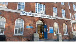
Western Eye Hospital
Marylebone Road
London
NW1 5QH
Main contact number
020 3312 6666
Travel options
Underground
Marylebone underground station, situated in zone one on the Bakerloo line, is the closest underground station to Western Eye Hospital. It is approximately a four minute walk to the hospital.
MAP AND DIRECTIONS
Baker Street underground station which is situated in zone one on the Bakerloo, Circle, Hammersmith & City, Jubilee and Metropolitan lines, is approximately an eight minute walk from the hospital.
Paddington station operates a taxi rank, however we always recommend that you pre-book a taxi before you travel.
There is a small drop-off and pick-up point outside the main entrance to the hospital, however please bear in mind this space is also used by ambulances.
Please use the Transport for London Santander cycle map to help you find a bike. There are lots of Santander cycle docking stations near Western Eye Hospital, including:
Seymour Place docking station which is a four minute walk from the hospital
Shouldham Street docking station which is a four minute walk from the hospital
Bell Street docking station which is a five minute walk from the hospital
Boston Place docking station is a seven minute walk from the hospital
Dorset Square docking station is a seven minute walk from the hospital
Travel by car
Whenever possible, we strongly encourage you to use public transport to travel to and from our hospitals. We do not have any onsite car parking spaces at Western Eye Hospital. If you decide to travel by car, please plan your journey in advance.
Please be aware that the Western Eye Hospital is situated inside the congestion charge zone. You can find more details here.
Ultra Low Emission Zone (ULEZ) daily charge
All of our hospitals are within the Ultra Low Emission Zone (ULEZ) which means that if you drive to your appointment, or are driven by a family member or friend, your car will need to meet the ULEZ emissions standards otherwise, you will have to pay a £12.50 daily charge. NHS patients who meet specific health-related criteria can reclaim the daily charge via the hospital. To find out more please read our Reclaiming the Ultra Low Emission Zone (ULEZ) charge leaflet.